

At a glance
- Era
- The Crusades, Ayyubids and Mamluks
- Region
- al-Andalus & Europe
Quick facts
- Domain
- Navigation, cartography and geography
- Kind
- System
- First attested
- January 1154 CE · Shawwal 548 AH (derived)
- Era
- Middle period
- Where
- Palermo
- Described in
- Nuzhat al-Mushtaq fi ikhtiraq al-afaq
- Attribution
- Improvement
Who made it
- Al-Idrisi, Muhammad ibn Abd Allah Inventor
- Roger II of Sicily Commissioner
The claim and its basis
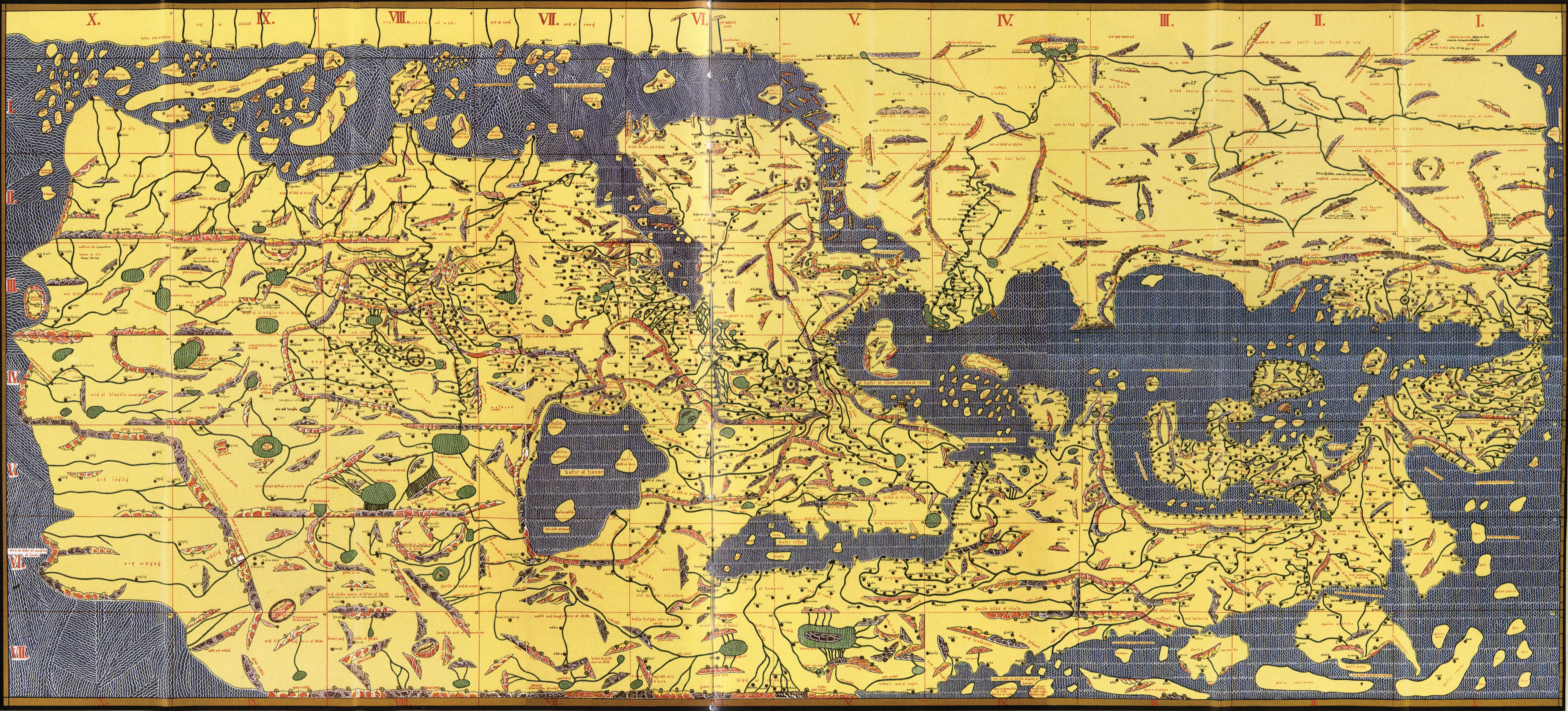
For Roger II, al-Idrisi drew the inhabited world on a silver disc and in a book that divides each of the seven climes into ten sections, each with its own map and description, joining the knowledge of earlier geographers with travellers' reports in seventy connected maps.
Al-Idrisi was not the first to draw the earth or to divide it into climes. He says himself that scholars divided the inhabited quarter into seven climes by imaginary lines known through astronomy; he opens his account of the earth's form 'as Ptolemy named it'; and he names the books Roger consulted: al-Mas'udi, al-Jayhani, Ibn Khurradadhbih, al-Udhri, Ibn Hawqal, Khanakh ibn Khaqan al-Kimaki, al-Ya'qubi, Qudama, Ptolemy, Orosius and others. What is new is set out in the book itself: the way the material was gathered, by questioning travellers together and one by one, keeping what they agreed on and dropping what they disputed, and testing the distances on a drawing board; and the division of each clime into ten sections of set length and breadth, each with a map followed by its description, seventy maps in all. TDV counts him among the best-known followers of Ptolemy's school and notes that he made important changes to Ptolemy's maps.
Sources: Al-Idrisi, Nuzhat al-Mushtaq fi ikhtiraq al-afaq (Cairo: Maktabat al-Thaqafa al-Diniyya, 2002), 2 vols. · İDRÎSÎ, Şerîf — TDV İslâm Ansiklopedisi (Ramazan Şeşen) · Nuzhat al-mushtaq (al-Idrisi), Rome 1592 · Wikimedia Commons (file pages, CC BY-SA and CC BY licences)
Before it
- Ptolemy's Geography and its maps
- The division of the inhabited quarter into seven climes
- The Muslim geographers' books of routes and realms: Ibn Khurradadhbih, al-Jayhani, Ibn Hawqal, al-Ya'qubi and al-Mas'udi
- The reports of travellers
Built on it
- Uns al-muhaj wa rawd al-faraj, al-Idrisi's own shorter version with additions
- Abridgements of Nuzhat al-mushtaq, and Abu al-Fida's quotations from al-Idrisi in Taqwim al-buldan
- The Rome Arabic printing of 1592 and its Latin translation, Geographia Nubiensis (Paris 1619)
- The complete edition of the text (Leiden 1970–1984) and Konrad Miller's redrawing of the maps
How it works
Summary
At Palermo in the middle of the twelfth century, the geographer al-Sharif al-Idrisi made for Roger II, king of Sicily, a picture of the whole inhabited world. It had two parts: a great disc of pure silver engraved with the seven climes, their lands, rivers and routes, and a book to go with it, Nuzhat al-mushtaq fi ikhtiraq al-afaq, in which each clime is cut into ten sections and each section has its own map followed by a description, seventy maps in all 1 2. The material was gathered over some fifteen years from earlier books and from travellers, keeping only what they agreed on, and the book was named in the first ten days of January, in Shawwal 548 AH 1, which TDV gives as January 1154 3.
What it is
The work is a map and a book that explain each other. In al-Idrisi's account the silver disc weighed four hundred Roman pounds, each of one hundred and twelve dirhams, and the workmen engraved on it the seven climes with their lands and regions, coasts and hinterlands, gulfs and seas, rivers, cultivated and empty places, the roads between them with their distances in miles, and the harbours, following what had been drawn on a drawing board 4. The king then ordered a book to describe what the disc could not show: the lands' conditions, crops, buildings, crafts, trade and wonders, and their peoples' appearance, dress, beliefs and languages 5.
Inside the book the drawing is broken into parts. To draw the cities of the climes, al-Idrisi explains, each clime was divided along its length into ten parts of set length and breadth, and each part was drawn with its cities, districts and settlements, so that a reader could see what lay beyond his own sight or beyond roads he could not travel. There are seventy such maps, besides the two edges of the habitable world, the empty south and the empty north 6. After each map comes the description of its part 7. TDV adds that the book also has a world map in its preface 3.
The world before it
Muslim geographers had been writing books of routes and realms for three centuries before al-Idrisi. The preface names the books Roger had searched: those of al-Mas'udi, Abu Nasr al-Jayhani, Ibn Khurradadhbih, Ahmad ibn Umar al-Udhri, Ibn Hawqal, Khanakh ibn Khaqan al-Kimaki, Musa ibn Qasim al-Qardi, al-Ya'qubi, Ishaq ibn al-Hasan the astronomer, Qudama al-Basri, Ptolemy and Orosius 8. The habit of dividing the inhabited quarter of the earth into seven climes, bands running from west to east, imaginary lines known through astronomy, was already old: al-Idrisi presents it as the scholars' division 9. He opens his own account with "the form of the earth called geography, as Ptolemy named it" 5.
What the old books lacked, in Roger's judgement, was detail. He found the subject in them "not explained, not complete, not set out", but neglected 4.
The story
Al-Idrisi was born at Ceuta in 493 AH, studied at Córdoba and travelled widely in al-Andalus and North Africa; in the early years of Roger II's reign (1130–1154) he settled at Palermo, the capital of Sicily, and lived there 3.
His preface tells the story of the work as the story of the king. Roger, he writes, was learned in the mathematical sciences, and when his realm had grown he wanted to know its lands with certainty: their borders and routes by land and sea, which clime each lay in, and what seas and gulfs belonged to it, along with the other lands of the seven climes 10. The books did not satisfy him. So he summoned those who knew the subject and questioned them, and when they too fell short, he summoned the people who had travelled the lands and questioned them together and one by one. What they agreed on he kept; what they disputed he set aside. He went on in this way for about fifteen years 4.
Then he wanted to be sure of the lengths and breadths of the distances they had reported. A drawing board was brought, and he tested the figures on it, step by step, with iron measuring tools, weighing them against the books. When he was satisfied, he ordered the silver disc, had the climes engraved on it from the board, and ordered the book 4. Al-Idrisi writes that the book was named in the first ten days of January, in Shawwal 548, and that he carried out the order 5.
The maker(s)
Al-Idrisi wrote the book and drew its maps; he descended from Idris I, founder of the Idrisid dynasty 3. He also wrote a shorter, expanded geography and a book on medicinal plants 3.
Roger II commissioned the work. Al-Idrisi, writing at his court, gives him a long string of titles, king of Sicily, Italy, Lombardy and Calabria, and calls him the champion of the Christian religion 11. In the preface it is Roger who gathers the books and the travellers and tests the distances; al-Idrisi presents himself as the one who carried out his order 12.
How it works
The book begins with the shape of the earth. The earth, al-Idrisi writes, is round like a ball, with the water clinging to it, and earth and water rest in the middle of the heavens like the yolk in an egg 5. The inhabited quarter is divided into seven climes, each running from west to east; in each are cities, forts, villages and peoples unlike one another, with mountains, rivers, lakes, mines, plants and animals 9. Seven seas cut through the climes 9.
Each clime is then split along its length into ten parts. Each part is a map, and each map is followed by a written description of its cities, peoples, dress, roads with their miles and farsakhs, and the wonders travellers had seen 2. Placed side by side, the seventy maps make one map of the whole known world. TDV describes the plan the same way: the northern half of the earth studied in seven climes from the equator northwards, each clime divided from west to east into regions 3.
The spread
The book travelled in copies. TDV records two abridgements of it, quotations from al-Idrisi in Abu al-Fida's Taqwim al-buldan, and a copy with illustrated pages in the Köprülü Library in Istanbul 3. In Europe a selection from it was printed in Arabic at Rome in 1592 and translated into Latin by Gabriel Sionita and Johannes Hesronita as Geographia Nubiensis (Paris 1619) 3. The museum holds a record for the Rome 1592 printing.
What it was built on
- Ptolemy's Geography and its maps: al-Idrisi opens with the earth's form "as Ptolemy named it" and lists Ptolemy among Roger's books 1; TDV says he drew on Ptolemy's Kitab al-Jughrafiya and made important changes to Ptolemy's maps 3.
- The division of the inhabited quarter into seven climes 9.
- The Muslim geographers' books of routes and realms, Ibn Khurradadhbih, al-Jayhani, Ibn Hawqal, al-Ya'qubi and al-Mas'udi among them 8 3.
- The reports of travellers, gathered and compared at Roger's court 4.
What was built on it
- Uns al-muhaj wa rawd al-faraj, al-Idrisi's own shorter version with additions, which speaks of an eighth clime south of the equator 3.
- Two abridgements of the book, and Abu al-Fida's quotations from al-Idrisi in Abu al-Fida's Taqwim al-buldan 3.
- The Rome Arabic printing of 1592 and its Latin translation, Geographia Nubiensis (Paris 1619) 3.
- Pierre-Amédée Jaubert's French translation (Paris 1836–1840), the complete Arabic text (Leiden 1970–1984) and Konrad Miller's redrawing of the maps in Mappae Arabicae (Stuttgart 1926–1931) 3.
Impact on daily life
The book was written for a reader who could not go everywhere: its maps show "what was hidden from his sight or beyond his knowledge, or what he could not reach because the roads were hard and the peoples different" 6. For each section it gives the roads with their distances in miles and farsakhs, the goods brought in and carried out, and the crafts of each place 13, the kind of knowledge a ruler, a merchant or a traveller needed.
How it changed history
TDV counts Nuzhat al-mushtaq among the most comprehensive general and systematic geographies of the earth written in the medieval Islamic world, and the first work to give information about Europe close to the truth; it says the maps of many countries, Western Europe above all, were drawn in it for the first time in a form that can be called faithful 3. It also notes the limits: its reports on the lands of the Turks are fuller than those of earlier geographers but at times blurred by legend 3. Printed at Rome and translated at Paris in the early seventeenth century, it became one of the Arabic geographies European scholars could read 3.
Who invented it?
Not the map of the world itself, and not the seven climes: al-Idrisi presents both as inherited, from the scholars and from Ptolemy 14, and names the Muslim and Greek books his patron consulted 8. TDV places him among the best-known followers of Ptolemy's school of geography, one who made important changes to Ptolemy's maps 3.
What the book claims as its own is the method and the plan: gathering travellers' reports for some fifteen years, keeping only what they agreed on, testing the distances on a drawing board 4, and laying the world out as seventy sectional maps of set length and breadth, each followed by its description 2. In the preface Roger drives the inquiry and al-Idrisi writes the book and draws the maps; the museum records al-Idrisi as maker and Roger as the patron who commissioned the work.
Today
Al-Idrisi's maps are no longer used to find the way, but the work has not been lost. The book survives in manuscripts, its full Arabic text has been in print since the Leiden edition of 1970–1984, reprinted at Beirut in 1989, and its seventy maps, redrawn by Konrad Miller, were reprinted as Weltkarte des Arabers Idrisi vom Jahre 1154 (Stuttgart 1981) 3. The sources read for this record say nothing of what became of the silver disc.
Surviving examples
- A manuscript in the Köprülü Library, Istanbul (no. 955), whose opening pages and two illustrated pages (fols. 341b–342a) are reproduced by TDV 3.
- The Rome Arabic printing of 1592 3.
- Konrad Miller's assembled copy of the seventy maps, with the names in Latin letters and south at the top, as al-Idrisi drew it 15.
In culture
The book has many names. Al-Idrisi called it Nuzhat al-mushtaq fi ikhtiraq al-afaq, "the pleasure of one who longs to cross the horizons" 5; it was also known as Kitab Rujar and al-Kitab al-Rujari, the Book of Roger, and in Latin Europe as Geographia Nubiensis 3. TDV notes that most Muslim biographers pass over al-Idrisi in silence; some modern scholars put this down to his service with the Norman kings, while TDV thinks the main reason was that geography and botany were little prized at the time, since those who did write about him, Imad al-Din al-Isfahani and al-Safadi, praise him chiefly as a man of letters 3.
For young readers
About nine hundred years ago a Muslim scholar named al-Idrisi lived on the island of Sicily. The island's king, Roger, wanted to know the whole world, so he gathered the geographers' books and asked travellers about lands and roads, keeping what they agreed on. The world was then engraved on a great disc of silver, and al-Idrisi wrote a book with seventy maps, each followed by a description of its lands and people 12 6.
References
- Al-Sharif al-Idrisi, Nuzhat al-mushtaq fi ikhtiraq al-afaq, Cairo: Maktabat al-Thaqafa al-Diniyya, 2002: preface and introduction, scan pp. 3–14. 16
- Ramazan Şeşen, "İDRÎSÎ, Şerîf", TDV Encyclopedia of Islam, vol. 21 (2000), pp. 493–495, online edition. 3
- Al-Idrisi, Kitab Nuzhat al-mushtaq, Rome 1592. 17
- Wikimedia Commons, "TabulaRogeriana.jpg", Konrad Miller's copy, public domain. 15
Connections
- Invented by
- Al-Idrisi, Muhammad ibn Abd Allah
- Described by
- Nuzhat al-Mushtaq fi ikhtiraq al-afaq
People and things also explored
Al-Idrisi, Muhammad ibn Abd Allah· Nuzhat al-Mushtaq fi ikhtiraq al-afaq· Al-Idrisi at Roger II's court, Palermo· Nuzhat al-Mushtaq completed, 549 AH· Ceuta
Sources
- Al-Idrisi, Nuzhat al-Mushtaq fi ikhtiraq al-afaq (Cairo: Maktabat al-Thaqafa al-Diniyya, 2002), 2 vols. , pp. 6–7
- Al-Idrisi, Nuzhat al-Mushtaq fi ikhtiraq al-afaq (Cairo: Maktabat al-Thaqafa al-Diniyya, 2002), 2 vols. , pp. 13–14
- İDRÎSÎ, Şerîf — TDV İslâm Ansiklopedisi (Ramazan Şeşen) , pp. 493–495
- Al-Idrisi, Nuzhat al-Mushtaq fi ikhtiraq al-afaq (Cairo: Maktabat al-Thaqafa al-Diniyya, 2002), 2 vols. , p. 6
- Al-Idrisi, Nuzhat al-Mushtaq fi ikhtiraq al-afaq (Cairo: Maktabat al-Thaqafa al-Diniyya, 2002), 2 vols. , p. 7
- Al-Idrisi, Nuzhat al-Mushtaq fi ikhtiraq al-afaq (Cairo: Maktabat al-Thaqafa al-Diniyya, 2002), 2 vols. , p. 13
- Al-Idrisi, Nuzhat al-Mushtaq fi ikhtiraq al-afaq (Cairo: Maktabat al-Thaqafa al-Diniyya, 2002), 2 vols. , p. 14
- Al-Idrisi, Nuzhat al-Mushtaq fi ikhtiraq al-afaq (Cairo: Maktabat al-Thaqafa al-Diniyya, 2002), 2 vols. , pp. 5–6
- Al-Idrisi, Nuzhat al-Mushtaq fi ikhtiraq al-afaq (Cairo: Maktabat al-Thaqafa al-Diniyya, 2002), 2 vols. , p. 9
- Al-Idrisi, Nuzhat al-Mushtaq fi ikhtiraq al-afaq (Cairo: Maktabat al-Thaqafa al-Diniyya, 2002), 2 vols. , p. 5
- Al-Idrisi, Nuzhat al-Mushtaq fi ikhtiraq al-afaq (Cairo: Maktabat al-Thaqafa al-Diniyya, 2002), 2 vols. , p. 4
- Al-Idrisi, Nuzhat al-Mushtaq fi ikhtiraq al-afaq (Cairo: Maktabat al-Thaqafa al-Diniyya, 2002), 2 vols. , pp. 5–7
- Al-Idrisi, Nuzhat al-Mushtaq fi ikhtiraq al-afaq (Cairo: Maktabat al-Thaqafa al-Diniyya, 2002), 2 vols. , pp. 7, 14
- Al-Idrisi, Nuzhat al-Mushtaq fi ikhtiraq al-afaq (Cairo: Maktabat al-Thaqafa al-Diniyya, 2002), 2 vols. , pp. 7, 9
- Wikimedia Commons (file pages, CC BY-SA and CC BY licences)
- Al-Idrisi, Nuzhat al-Mushtaq fi ikhtiraq al-afaq (Cairo: Maktabat al-Thaqafa al-Diniyya, 2002), 2 vols. , pp. 3–14
- Nuzhat al-mushtaq (al-Idrisi), Rome 1592
Cite this page
islam.museum contributors. “Al-Idrisi's world map and the Book of Roger (Tabula Rogeriana)”. islam.museum, https://islam.museum/en/invention/tabula-rogeriana/. CC BY-SA 4.0. Last updated 2026-11-05.
Improve this page on GitHub · Report an error · Help complete it · JSON